Vegetation includes all plants from evergreen forests to grassy meadows and cropland. All types of plants play a role in both the water cycle and the earth’s energy balance. They affect weather and climate mostly through evapotranspiration and albedo.
Effects on Weather and Climate
With vegetation covering about 20% of our planet, it’s no surprise that plants affect climate. However, it is surprising how much plants affect weather. Plants process and release water vapor (necessary for cloud formation) and absorb and emit energy used to drive weather. Plants also produce their own micro-weather by controlling the humidity and temperature immediately surrounding their leaves through transpiration. Most plants and forest soils have a very low albedo, (about .03 to .20) and absorb a large amount of energy. However, plants don’t contribute to overall warming because the excess warmth is offset by evaporative cooling from transpiration.
Since climate is basically an average of the weather over a long period of time, vegetation is important to climate. In fact, the process of photosynthesis is responsible for building up atmospheric oxygen to the level we enjoy today (21% concentration). Plants also help keep our climate stable over time by offsetting temperature and moisture fluctuations through transpiration. Plants also use carbon dioxide during photosynthesis, which slightly offsets the amount of greenhouse gas being released in the atmosphere through the burning of fossil fuels. Vegetation is necessary for normal weather and climate.
Land Use
There are nearly 2 billion acres of land in the continental United States. Land use classifies the types of vegetation on the land. In the past thirty years, there has been an increase in developed land and a decrease in cultivated crop land. An increase in developed land means more areas are covered by buildings, concrete and asphalt.
It is interesting to note that historical land use changes have also affected the climate of the Southeast. In Georgia, for example, around 1900 there were large areas of bare ground associated with cotton fields and other crops. By the late 1900s, most of Georgia (over 70 percent) had reverted to pine and deciduous forests once cotton was no longer farmed due to the boll weevil (beetle which feeds on cotton buds and flowers) and soil degradation. Some climatologists think that the slight cooling of the Southeast over the 1900s may have been due in part to the higher evapotranspiration and cooler conditions associated with forests compared to bare ground in cropland.
The more recent increase in developed land, especially around urban areas, causes a “heat island” effect, and large cities with no exposed ground or vegetation become very hot during the day. The lack of vegetation means there is no transpiration to cool the air. Also, asphalt has a very low albedo and absorbs a lot of sunlight, which adds to the excessive heat. The concrete and asphalt release their heat slowly at night, too, leading to warmer conditions overnight as well as during the day. Uncultivated crop land also stays warmer due to the lack of transpiration, but doesn’t get as hot as developed areas.
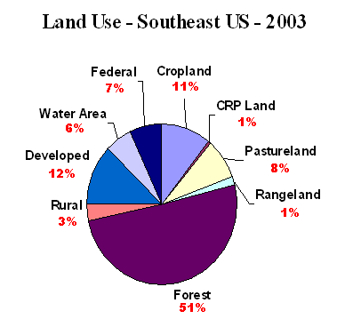
Figure B shows the distribution of land use in the Southeast (AL, FL, GA, NC, SC and VA). On average, the Southeast has twice as much developed land as the rest of the United States, although this is offset by the fact that over half of the land in the Southeast is forest. Forests are beneficial because they use copious amounts of carbon dioxide, as well as mitigating heat through transpiration.
How does this relate to agriculture?
Farmers are responsible for maintaining a majority of the cropland vegetation in arable regions of the world. Vegetation (or the lack of it) is a key factor affecting weather patterns and micro-climates. The following factors are affected by vegetation:
(1) Plant covers and crops are inherently responsible for a vast majority of the water storage and usage. When irrigation is taken out of the equation, rain, snow, fog, dew, frost and soil water are all used and captured by vegetation. Some of this water is intercepted by the leaves themselves, and some of the water that infiltrates the soil is absorbed by plant roots. When water is available in excess, plants can transpire large volumes of water as a by-product of photosynthesis. This in turn causes evaporative cooling in the atmosphere directly surrounding the crop.
(2) Vegetation contributes to the level of carbon dioxide that is present in the atmosphere. Seasonal variations have shown that higher levels of CO2 are measured in the early-mid part of the growing season. There are also daily variations in CO2, with the highest levels measured during the day.
(3) Radiation measurements within a crop or vegetated area reveal a complex relationship between absorption, reflection, transmission and emission. The albedo of a crop is lower than the sum of all of the leaves in the canopy due to differences in crop architecture and angle of solar radiation. Most individual leaves have an albedo of about 0.25, but the albedo for a crop is less and depends upon crop height. For a crop of 1m in height, the surface albedo is between 0.18 and 0.25. However, this value is dependent upon the vegetation type. If leaves are wilted, or if the soil is exposed beneath the canopy this value can be different. Also, this albedo measurement is the one taken at mid-day. Early morning and late day measurements of albedo are much higher and the values follow the position of the sun in the sky. Also, tropical measurements of albedo are usually less that for a similar vegetated surface found at higher latitudes.

.JPG)
No comments:
Post a Comment