The main feature is an immense high plateau covering most of the country, encircled by the
second feature, the coastal lowland regions.
The third one consists of a series of mountain ranges rising quite abruptly along the inland perimeter of the coastal lowlands, separating them from the high plateau.
This last one is well-known as The Great Escarpment, with mountain heights ranging from 2,000 to 3.300 meters.
The interior highlands of South Africa are part of the African plateau extending north right up to the Sahara desert regions.
With its total land area of 1,219,090 kilometers South Africa is one-eights the size of the US and one-third the size of Europe and.
Rainbow over Waenhuiskrans
Photograph by: Steve Crane - Geography of South Africa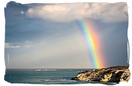
The Name...
What is in a name?....one could ask. In South Africa the answer could be: "a rainbow". A rainbow of 11 different official languages and 7 different ways of saying "South Africa".
Official abbreviation: RSA
Short abbreviation: SA
Noun and adjective: SOUTH AFRICAN(S)
The ISO country code is: ZA
Internet country code is: .CO.ZA
Learn more about the geography of South Africa watching this video
The Location...
You will find South Africa at the southern tip of the African continent, stretching north to south for approximately 1,600 km (994 mi) between 22 and 35 degrees latitude, and east to west also for about 1,600 km (994 mi) between 17 and 33 degrees longitude.
The Tropic of Capricorn slices through the extreme north of the country at 23 degrees 26’ 22” latitude.
The interactive possibilities of the map below are quite stunning. Put the cursor of your mouse on any spot on the map you like to explore and follow the instructions underneath the map.
You will be able to zoom in on the major towns and cities as close as street level. If you then click on the map button in the right hand
Interactive map of South Africa
Geography of South Africa
Tips for navigating the map.
Come face to face with
an amazing variety of South Africa's animals and scenery in this video
The Land...
South Africa's entire land surface comprises 1,219,912 sq km (460,693 sq mi), 40 percent of it lies 1210 m (3970 ft) above sea level with as highest point Mount Njesuthi in the Drakensberg mountains at 3,446 m (11,396 ft) above sea level.
Included are the Marion and Prince Edward islands which became part of South Africa in 1947 and are situated in the Atlantic ocean 1,920 km (1,193 mi) south-east of cape Town.
All together it makes South Africa the 26th largest country in the world. But to get a better idea, think in terms of the combined size of France, Italy, Germany, Holland and Belgium together or for our American visitors two times the size of the State of Texas.
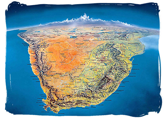
Satellite view of South Africa showing the major
topographic features
(Click on the picture to enlarge, then click on it again to enlarge it even further)
The Boundaries...
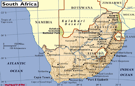
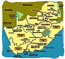
Besides a coastline of 2,798 km (1,738 mi) with the Atlantic ocean to the west and the Indian ocean to the east, South Africa has common borders with the republics of Zimbabwe 225 km (139 mi), Mozambique 491 km (305 mi), Namibia 967 km (600 mi), Botswana 1,840 km (1,143 mi) and the kingdoms of Lesotho 909 km (564 mi), and Swaziland 430 km (267 mi).
The kingdom of Lesotho is an enclave within South African territory. The same applies for the kingdom of Swaziland, except for a small stretch of border that it has with Mozambique. It all adds up to a total inland boundary of 4,872 km (3,027 mi), and a total circumference of our country of 5,331 km (3,312 mi).
Map of South Africa showing its boundaries
Geography of South Africa
The Administration...
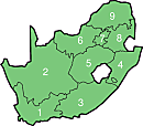
South Africa has nine provinces and three capitals.
The provinces each with its provincial capital are, Gauteng and Johannesburg (7), Limpopo and Polokwane (9), Mpumalanga and Nelspruit (8), North-West province and Mmabatho (6), Free State and Bloemfontein (5), Eastern Cape and Bisho (3), Northern Cape and Kimberley (2), Western Cape and Cape Town (1) and Kwazulu-Natal and Pietermaritzburg (4). The numbers correspond with those on the map below.
The national capitals are, Pretoria (administrative capital), Cape Town (legislative capital) and Bloemfontein (judicial capital).
Map of South Africa showing the country's provincial structure
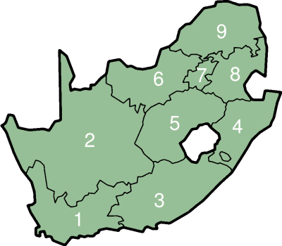
Geography of South Africa, find more maps
The Coastline...
South Africa's coastline of 2,798 (1,738 mi) features only a small number of bays and but one natural harbor, Saldanha Bay in the Western Cape.
The other major ports, following the coastline clockwise are Richardsbay and Durban in Kwazulu-Natal, East London, Port Elizabeth and Mosselbay in the Eastern Cape and Cape Town in the Western cape. A total of 98 % of all South Africa's exports are conveyed by sea through these seven ports.
The two most distinctive promontories on our country's coastline are the Cape peninsula, with the Cape of Good Hope at its southern tip and Cape Agulhas at the most southern tip of the African continent. Cape Agulhas is the place where the two oceans, the Atlantic ocean and the Indian ocean, meet.
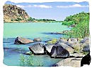
Wilderness beach near GeorgeGeography of South Africa

The Rivers...
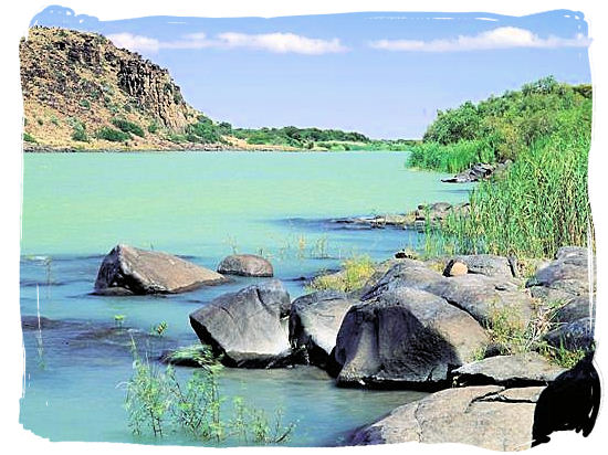
The Orange, Vaal and Limpopo are the three main rivers in South Africa. The longest of the three is the Orange river, which has its source in the Kingdom of Lesotho where it is called the Senqu river. With its westernmost section forming the border with Namibia, it flows north-west for about 2,100km (1,300 mi) towards the Atlantic ocean.
The Vaal river has its origin in the Drakensberg mountains in the Mpumalanga province. It is 1,120 km (695 mi) long and flows south west to where it unites with the Orange river of which it a tributary.
The Limpopo river rises in the Witwatersrand region of South Africa, where it is called the Crocodile river. It flows in a circular route of about 1,700 km (1,056 mi), first to the Botswana border in the north east, where it turns east forming the border with Botswana and Zimbabwe to where it enters the country of Mozambique, finally emptying itself in the Indian ocean.
The mighty Orange river flowing wide and slowly below the Vanderkloof Dam
copyright © South African tourism - South Africa Geography
The Lakes...
The only natural lake to be found in South Africa is the Fundudzi Lake which is situated in the Soutpansberg mountains in the far north-east of the Limpopo province. Besides Fundudzi there are no true natural inland lakes of any significance in South Africa. Rivers are the main source of water.
What you will find in our country are many large artificial lakes or dams for the storage of the country's water supplies. They are formed by constructing huge dam walls in the flow of rivers to regulate their natural variable flow and the transfer of water between catchment areas.
There are 26 major dams in South Africa, ranging in capacity from the Gariep dam in the Free State at 5,341 million cubic metres, down to the Midmar dam in Kwazulu-natal at 175 million cubic meters.
Hartbeespoort Dam, a lake of great scenic beauty, is situated west of Pretoria
copyright © South African tourism - Geography of South Africa
The third one consists of a series of mountain ranges rising quite abruptly along the inland perimeter of the coastal lowlands, separating them from the high plateau.
This last one is well-known as The Great Escarpment, with mountain heights ranging from 2,000 to 3.300 meters.
The interior highlands of South Africa are part of the African plateau extending north right up to the Sahara desert regions.
With its total land area of 1,219,090 kilometers South Africa is one-eights the size of the US and one-third the size of Europe and.
 The Name |
 The Location |
 The Land |
 The Boundaries |
 The Administration |
 The Coastline |
 The Rivers |
 The Lakes |
Photograph by: Steve Crane - Geography of South Africa
What is in a name?....one could ask. In South Africa the answer could be: "a rainbow". A rainbow of 11 different official languages and 7 different ways of saying "South Africa".
- English = South Africa
- Southern Sotho = Afrika Borwa
- Northern Sotho = Afrika Borwa
- Tswana = Afrika Borwa
- Xhosa = Mzantsi Afrika
- Zulu = Ningizimu Afrika
- Swati = Ningizimu Afrika
- ndebele = Ningizimu Afrika
- Venda = Afurika Tshipembe
- Tsonga = Afrika Dzonga
- Afrikaans = Suid Afrika
Official abbreviation: RSA
Short abbreviation: SA
Noun and adjective: SOUTH AFRICAN(S)
The ISO country code is: ZA
Internet country code is: .CO.ZA
You will find South Africa at the southern tip of the African continent, stretching north to south for approximately 1,600 km (994 mi) between 22 and 35 degrees latitude, and east to west also for about 1,600 km (994 mi) between 17 and 33 degrees longitude.
The Tropic of Capricorn slices through the extreme north of the country at 23 degrees 26’ 22” latitude.
The interactive possibilities of the map below are quite stunning. Put the cursor of your mouse on any spot on the map you like to explore and follow the instructions underneath the map.
You will be able to zoom in on the major towns and cities as close as street level. If you then click on the map button in the right hand
Geography of South Africa
- The three buttons at the right-hand top corner of the map allow you to view either the geographical map, the satellite picture or a combination of both.
- The button cluster in the left hand top corner will enable you to zoom in or out. On the map you can use the PLUS (+) key to Zoom In for more detail, or the MINUS (-) key to Zoom Out for a bigger picture of the region in relation to the rest of South Africa.
- Alternatively, put the cursor on a spot on the map you want to explore and double click with the right hand mouse button again and again, keeping the cursor on the same spot.
- You will also be able to move the map left and right and up and down by clicking the left-hand mouse button and moving the cursor on the map.
- Click on the refresh button of your browser to return to the original map.
an amazing variety of South Africa's animals and scenery in this video
South Africa's entire land surface comprises 1,219,912 sq km (460,693 sq mi), 40 percent of it lies 1210 m (3970 ft) above sea level with as highest point Mount Njesuthi in the Drakensberg mountains at 3,446 m (11,396 ft) above sea level.
Included are the Marion and Prince Edward islands which became part of South Africa in 1947 and are situated in the Atlantic ocean 1,920 km (1,193 mi) south-east of cape Town.
All together it makes South Africa the 26th largest country in the world. But to get a better idea, think in terms of the combined size of France, Italy, Germany, Holland and Belgium together or for our American visitors two times the size of the State of Texas.
(Click on the picture to enlarge, then click on it again to enlarge it even further)

Besides a coastline of 2,798 km (1,738 mi) with the Atlantic ocean to the west and the Indian ocean to the east, South Africa has common borders with the republics of Zimbabwe 225 km (139 mi), Mozambique 491 km (305 mi), Namibia 967 km (600 mi), Botswana 1,840 km (1,143 mi) and the kingdoms of Lesotho 909 km (564 mi), and Swaziland 430 km (267 mi).
The kingdom of Lesotho is an enclave within South African territory. The same applies for the kingdom of Swaziland, except for a small stretch of border that it has with Mozambique. It all adds up to a total inland boundary of 4,872 km (3,027 mi), and a total circumference of our country of 5,331 km (3,312 mi).
Geography of South Africa
South Africa has nine provinces and three capitals.
The provinces each with its provincial capital are, Gauteng and Johannesburg (7), Limpopo and Polokwane (9), Mpumalanga and Nelspruit (8), North-West province and Mmabatho (6), Free State and Bloemfontein (5), Eastern Cape and Bisho (3), Northern Cape and Kimberley (2), Western Cape and Cape Town (1) and Kwazulu-Natal and Pietermaritzburg (4). The numbers correspond with those on the map below.
The national capitals are, Pretoria (administrative capital), Cape Town (legislative capital) and Bloemfontein (judicial capital).
Geography of South Africa, find more maps
South Africa's coastline of 2,798 (1,738 mi) features only a small number of bays and but one natural harbor, Saldanha Bay in the Western Cape.
The other major ports, following the coastline clockwise are Richardsbay and Durban in Kwazulu-Natal, East London, Port Elizabeth and Mosselbay in the Eastern Cape and Cape Town in the Western cape. A total of 98 % of all South Africa's exports are conveyed by sea through these seven ports.
The two most distinctive promontories on our country's coastline are the Cape peninsula, with the Cape of Good Hope at its southern tip and Cape Agulhas at the most southern tip of the African continent. Cape Agulhas is the place where the two oceans, the Atlantic ocean and the Indian ocean, meet.
The Orange, Vaal and Limpopo are the three main rivers in South Africa. The longest of the three is the Orange river, which has its source in the Kingdom of Lesotho where it is called the Senqu river. With its westernmost section forming the border with Namibia, it flows north-west for about 2,100km (1,300 mi) towards the Atlantic ocean.
The Vaal river has its origin in the Drakensberg mountains in the Mpumalanga province. It is 1,120 km (695 mi) long and flows south west to where it unites with the Orange river of which it a tributary.
The Limpopo river rises in the Witwatersrand region of South Africa, where it is called the Crocodile river. It flows in a circular route of about 1,700 km (1,056 mi), first to the Botswana border in the north east, where it turns east forming the border with Botswana and Zimbabwe to where it enters the country of Mozambique, finally emptying itself in the Indian ocean.
copyright © South African tourism - South Africa Geography
The only natural lake to be found in South Africa is the Fundudzi Lake which is situated in the Soutpansberg mountains in the far north-east of the Limpopo province. Besides Fundudzi there are no true natural inland lakes of any significance in South Africa. Rivers are the main source of water.
What you will find in our country are many large artificial lakes or dams for the storage of the country's water supplies. They are formed by constructing huge dam walls in the flow of rivers to regulate their natural variable flow and the transfer of water between catchment areas.
There are 26 major dams in South Africa, ranging in capacity from the Gariep dam in the Free State at 5,341 million cubic metres, down to the Midmar dam in Kwazulu-natal at 175 million cubic meters.
copyright © South African tourism - Geography of South Africa
No comments:
Post a Comment